
3D Modeling pt. 2
At BHC, we’re always looking to improve our understanding of a project and provide our customers with successful end results. Our engineering and survey segments are applying 3D modeling programs to projects to test the limitations of augmented reality viewing of projects from start to finish.
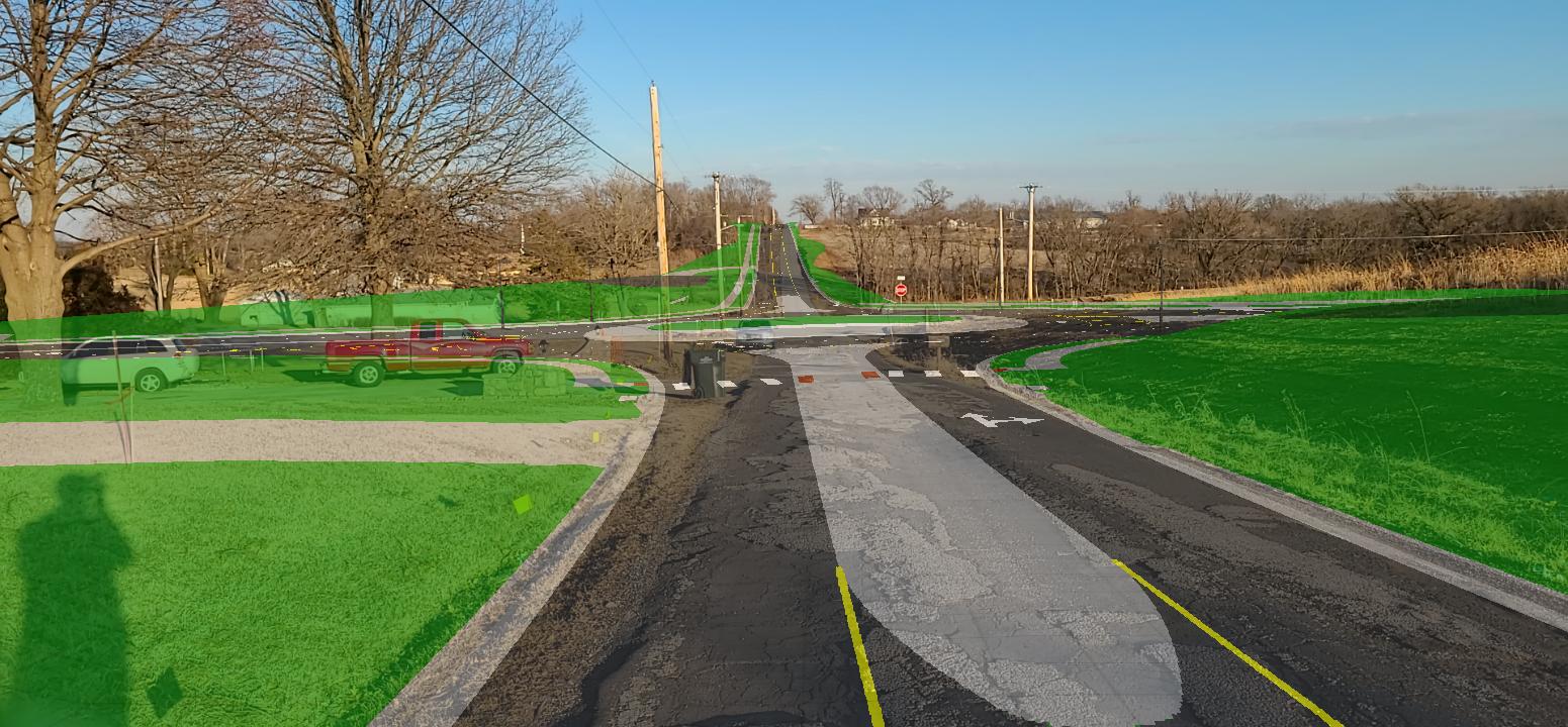
Our Public Works Segment has had the opportunity to use 3D modeling on the Riverview Crossroads project. BHC has been working with the City of Edwardsville, Kansas, to undergo roadway modernizations at 110th Street and Riverview Avenue. 3D modeling has been implemented into this site reconstruction by its use as a tool for measurement of success as the project moves into the construction phase.
Currently, models created in Civil 3D provide the design and plan production. These preliminary designs can be exported into InfraWorks to create a GIS based civil engineering design complete with minute details. The 3D models created in InfraWorks can then be exported into SiteVision. Which is a handheld device that displays geo-referenced 3D models in an augmented reality interface on-site.
Riverview Crossroads Project
On the Riverview Crossroads project, the team has been modeling different aspects of the design using each application (Civil 3D, InfraWorks, SiteVision). The first model created in Civil 3D was designed to show the topographic and line work. This otherwise flat design was then transferred into InfraWorks too bring the technical design to life. And demonstrate what the final project could look like.
When designing this model in InfraWorks, this made it easier to visually conceptualize the project and better understand the data. These models provide aid to the contractor during the different stages of the project for a universal comprehension.
The 3D models for this project could also extend beyond those who are familiar with the project’s design. For example, these 3D models could be presented at public meetings so residents in the area can understand through visual means why the city is moving forward with the project. Because of the realistic design capabilities of InfraWorks, anyone looking at the 3D models can understand the concept of what the final project will entail and all its moving parts for functionality.
In addition to better understanding the scope of the project, BHC has been implementing SiteVision within the Riverview Crossroads project to gain more experience with this technology as it is relatively new to the industry. This device has allowed for our design engineer to visit the site and compare the current developments to the model that was designed.
One element of the new site development was the extension of the existing roadway up a few feet above where it previously sat. In order to reroute stormwater, a culvert was placed below the newly lifted road. With the many parts that make up a finished project site, it’s important to confirm each step is done correctly for optimized results.
Our site engineer exported the 3D model created in InfraWorks into SiteVision to then use the augmented reality device to assess the placement of a culvert. Being able to see both the designed model and the current developments highlights any discrepancies between the model and the placement of these elements. Evaluating each new development alongside the model can limit miscommunication between contractors. This catches any errors early on before development continues to move forward.
Aside from assessing the culvert, the InfraWorks 3D model consisted of curb lines, sidewalks and a new roundabout among many other elements. Using SiteVision can help contractors understand what engineers communicate through 3D models and bridge the gap between different specialized individuals working on the project.
Trends in 3D Modeling
Augmented reality technology continues to grow in popularity in the AEC industry due to its effectiveness through all stages of a development. The possibilities extend to areas that have allowed for easier workflow demonstration. Without augmented technology in the construction process, practices for locating installations can be less accurate since the models are not accessed based off geolocation technology.
The more accurate these tools become, the lower the chances are for corrections later in the process of development. This brings forth several other benefits, like time reduction and quality control.
Staying up to date on trends within the AEC industry and using technology that provides satisfactory end results is a part of our “no problem” customer service guarantee. As we work to implement more 3D modeling processes into our projects, BHC will continue to evaluate the most useful tools for our customers. To learn more contact Randall Gorton, P.E., PTOE.